Click HERE to order
from our 2000+ page 2026 MASTER CATALOG
GIFT CERTIFICATES
Anchors & Accessories & Windlasses
Binoculars & Scopes
Boat Covers/Tarps & Accessories
Bow Thrusters
Charts & Fishing Charts
Capt. Segull's Nautical Charts-Click Below(bottom left )
Deck Plates, Bomar & Lewmar Hatches & Tackle Storage
Electrical and Battery Chargers, Switchs, Marine Batteries
Electronics
Fenders & Boat Hooks & Paddles
Fishing Gear and Fish Bags
Flags
Fuel Tanks & Accessories
Gauges & Instruments
Hardware and Padlocks
Holders/Storage & Drink Holders
Lighting
Maintenance: Caulks, Sealers & West System Epoy
RARITAN Marine Heads/Toilets/Hose and Maceraters
Miscellaneous
Plumbing, Fittings and Faucets
Pumps/Hose
Raritan ICE MAKER & Igloo Parts
Rope/Line/Chain
Life Vests-Life Rings-Horns-ACR Epirbs-
Seating
Teleflex(Dometic) Seastar Steering & Controls
Steps/Ladders and Boarding Handle & Dock Cart
Stereos and Speakers
Tables - NEW for 2026
Trailer Accessories and Winches, Jacks and Straps
Trim Tabs &Hatch Lifts by LENCO
Ventilation and AIR CONDITIONING
Life Vest, Life Rings, Cusions
Water Heaters by RARITAN
Watersports, Tubes, Scooters and Air Pumps
Winterizing and Cabin/Engine Room Heaters
Windshield Wipers and Accessories
Zincs/Anodes
X-Ternal Order From Print Catalog
ParaTech Sea Anchor *** SPECIAL DEAL! ***
GATOR GUARD - boat protection (CLICK HERE)
WELCOME TO:
SHOREWAY MARINE'S 2026 WEBSITE
EMAIL:customeservice@shorewaymarine.com
----
Request Our 2000+ Page
Master Catalog . Via Priority Mail for $3.50 to offset mailing costs
(Available March 2026)


PCI Compliance by
McAfee Secure&trade,IMMUNET & AVAST ;
Privacy Policy
©write 2009-2026
Shoreway Marine, LLC.*******
|
|
|
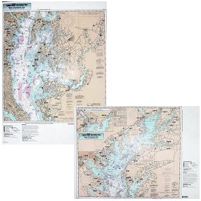
Captain Segull's Nautical Charts™ Upper Chesapeake Bay
|
| |
|
Quantity in Basket:
None
Code: csncCBU120
Price: $19.50
Shipping Weight: 9999.00 pounds
|
| |
 Captain Segull's Nautical Charts™ Captain Segull's Nautical Charts™
#CBU120
Upper Chesapeake Bay
High quality, laminated, waterproof and in full color. Average
chart size is 19" x 26". An inshore chart of the Upper Chesapeake Bay side A, extends from the C & D Canal to Sandy Point, MD, with an inset of the Susquehanna River and Northeast River. Side B, from Sandy Point, MD to Cove Point. MD. C & D Canal is on the DEL117 chart. All charts include GPS coordinates, wrecks, reefs, shoals, fishing areas, amenities and restrictions.
An order for multiple charts still ships at $7.95 total, for all charts.
Additional charges of $7.95 per chart will appear in your cart and your final
invoice screen, however the correct amount will be charged to your credit card.
|
|