Click HERE to order
from our 2000+ page 2026 MASTER CATALOG
GIFT CERTIFICATES
Anchors & Accessories & Windlasses
Binoculars & Scopes
Boat Covers/Tarps & Accessories
Bow Thrusters
Charts & Fishing Charts
Capt. Segull's Nautical Charts-Click Below(bottom left )
Clean and Protect & Washdown Hoses
Deck Plates, Bomar & Lewmar Hatches & Tackle Storage
Electrical and Battery Chargers, Switchs, Marine Batteries
Electronics
Fenders & Boat Hooks & Paddles
Fishing Gear and Fish Bags
Flags
Fuel Tanks & Accessories
Gauges & Instruments
Hardware and Padlocks
Holders/Storage & Drink Holders
Lighting
Maintenance: Caulks, Sealers & West System Epoy
Manuals for Engines by SEALOC
RARITAN Marine Heads/Toilets/Hose and Maceraters
Miscellaneous
Plumbing, Fittings and Faucets
Pumps/Hose
Racor Fuel Filters
Raritan ICE MAKER & Igloo Parts
Rope/Line/Chain
Life Vests-Life Rings-Horns-ACR Epirbs-
Seating
Teleflex(Dometic) Seastar Steering & Controls
Steps/Ladders and Boarding Handle & Dock Cart
Stereos and Speakers
Tables - NEW for 2025
Trailer Accessories and Winches, Jacks and Straps
Trim Tabs &Hatch Lifts by LENCO
Ventilation and AIR CONDITIONING
Life Vest, Life Rings, Cusions
Water Heaters by RARITAN
Watersports, Tubes, Scooters and Air Pumps
Winterizing and Cabin/Engine Room Heaters
Windshield Wipers and Accessories
Zincs/Anodes
X-Ternal Order From Print Catalog
ParaTech Sea Anchor *** SPECIAL DEAL! ***
GATOR GUARD - boat protection (CLICK HERE)
America 250 Flag
WELCOME TO:
SHOREWAY MARINE'S 2026 WEBSITE
EMAIL:customeservice@shorewaymarine.com
----
Request Our 2000+ Page
Master Catalog . Via Priority Mail for $3.50 to offset mailing costs
(Available March 2026)


PCI Compliance by
McAfee Secure&trade,IMMUNET & AVAST ;
Privacy Policy
©write 2009-2026
Shoreway Marine, LLC.*******
|
|
|
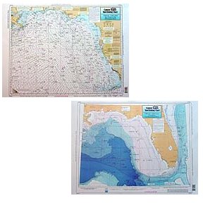
Captain Segull's Nautical Charts™ Key West, FL to Mississippi River, LA
|
| |
|
Quantity in Basket:
None
Code: csncKWM44
Price: $19.50
Shipping Weight: 9999.00 pounds
|
| |
 Captain Segull's Nautical Charts™ Captain Segull's Nautical Charts™
#KWM44
Key West, FL to Mississippi River, LA
High quality, laminated, waterproof and in full color. Average
chart size is 19" x 26". Offshore chart, covers half of the Gulf of Mexico. Side A is a new NOAA chart of the same area. Side B of the chart is a Bathymetric chart from Key West to the Mississippi River. All charts include wrecks, reefs, rigs, shoals, fishing areas, amenities and restrictions. For other charts in this area TAM40, SUW41, AA45, JAC46, PM47 and for Inshore chart of Tampa Bay, TMB135.
An order for multiple charts still ships at $7.95 total, for all charts.
Additional charges of $7.95 per chart will appear in your cart and your final
invoice screen, however the correct amount will be charged to your credit card.
|
|