Click HERE to order
from our 2000 page 2025 MASTER CATALOG
GIFT CERTIFICATES
Anchors & Accessories & Windlasses
Binoculars & Scopes
Boat Covers/Tarps & Accessories
Bow Thrusters
Charts & Fishing Charts
Capt. Segull's Nautical Charts-Click Below(bottom left )
Clean and Protect & Washdown Hoses
Deck Plates, Bomar & Lewmar Hatches & Tackle Storage
Electrical and Battery Chargers, Switchs, Marine Batteries
Electronics
Fenders & Boat Hooks & Paddles
Fishing Gear and Fish Bags
Flags
Fuel Tanks & Accessories
Gauges & Instruments
Hardware and Padlocks
Holders/Storage & Drink Holders
Lighting
Maintenance: Caulks, Sealers & West System Epoy
Manuals for Engines by SEALOC
RARITAN Marine Heads/Toilets/Hose and Maceraters
Miscellaneous
Plumbing, Fittings and Faucets
Pumps/Hose
Racor Fuel Filters
Raritan ICE MAKER & Igloo Parts
Rope/Line/Chain
Life Vests-Life Rings-Horns-ACR Epirbs-VIKING LIFE RAFTS
Seating
Teleflex(Dometic) Seastar Steering & Controls
Steps/Ladders and Boarding Handle & Dock Cart
Stereos and Speakers
Tables - NEW for 2024
Trailer Accessories and Winches, Jacks and Straps
Trim Tabs &Hatch Lifts by LENCO
Ventilation and AIR CONDITIONING
Life Vest, Life Rings, Cusions
Water Heaters by RARITAN
Watersports, Tubes, Scooters and Air Pumps
Winterizing and Cabin/Engine Room Heaters
Windshield Wipers and Accessories
Zincs/Anodes
X-Ternal Order From Print Catalog
ParaTech Sea Anchor *** SPECIAL DEAL! ***
WELCOME TO:
SHOREWAY MARINE 2025 WEBSITE
Request Our 2000 PAGE Master Catalog . Via Priority Mail for $3.50 to offset mailing costs
(Available March 2025)


PCI Compliance by
McAfee Secure&trade,IMMUNET & AVAST ;
Privacy Policy
© 2009-2025
Shoreway Marine, LLC.
|
|
|
Maptech® Waterproof Chart Long Island Sound
|
| |
|
Quantity in Basket:
None
Code: 157-WPC001
Price: $23.50
Shipping Weight: 1.00 pounds
|
| |
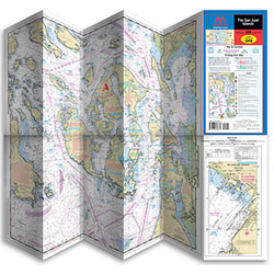
 Maptech® Waterproof Chart Maptech® Waterproof Chart
Unique “Flip Fold” Charts
Long Island Sound
Spread a Maptech® waterproof chart out to its full width to chart your entire course. Or keep it folded to 6” x 14” and flip to your favorite fishing hole. Charts are oriented to coastlines, just flip a fold to follow your course. Also, insets of harbor entrances and anchorage areas are oriented to their approaches. Because these charts are waterproof, you’ll be able to use them in any weather. And the extensive coverage in just one Maptech® waterproof chart will save your money compared to the cost of multiple paper charts covering the same area.
Other features you’ll find useful include:
Lat/Lon coordinates for navigation aids • Pre-plotted courses and distances • Boat launching ramps • Full-color fish illustrations.
DISCONTINUED for 2024
26737
|
|